Saturday, September 29, 2007
Itinerary Update 29 September, 2007
Thursday, September 27, 2007
Adelaide to Melbourne
The parks were purposely created to be very wide - in fact, farther than a rifle could shoot in those days. However, cannon could easily reach the opposite side, thus making the defense of the city (and thereby the new colony) that much easier for the settlers. It also made for a very pleasant "feel" within the city. This first pictures, however, are of the central Victoria Square.


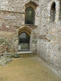
Typical early Adelaide architecture. Note any similarities to U.S. ante bellum architecture?

The Haigh Chocolate Factory - is just a few blocks up from where I stayed. They did not allow pictures of the actual factory itself, so this is the lobby shop and our enthusiastic (about chocolate) guide.

The founder was trained by the Lindt family in Switzerland, and the chocolate is some of the best in the world. They do not export their wares, and it's quite expensive to have it shipped to the USA, so ... I just ate enough for everyone I know.
Overviews of Adelaide:


The second overview was taken from Mt. Lofty (727 m or just over 2385 feet above sea level) (http://en.wikipedia.org/wiki/Mount_Lofty_Ranges). This is why the fellow from Adelaide got altitude sickness on the Kili climb, he thought. This was the highest point on earth he had ever been before the climb. The day we visited was cloudy, windy and cold (60 degrees at best). This was the best shot of the city I could get from that vantage point.
The western suburb of Adelaide is the seaside resort community of Glenelg. Note the palm trees. It has amazed me how prevalent they are in a part of the world that faces Antarctica.


Norfolk Island pines grow quite large, here. This picture is a bit overexposed.

Speaking of Antarctica, if you swim long enough from this beech, you'll reach it. This is the Great Southern Ocean to the Aussies.

And along the Great Southern Ocean are the famous 12 Apostles. There are now only 7, and were as many as 15 at one time. They were originally named "The Sow and Piglets," but that was changed to attract more tourists. They're in the right middle of this picture. This is the fastest eroding coastline in Australia, and these structures will not last very much longer.


Along The Great Ocean Road.


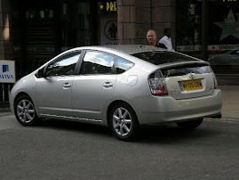
You'd think a driver would have seen this sign long before now, but they were along the Great Ocean Road, and not anywhere else that we could see!

Melbourne:
"Melbourne (pronounced /ˈmel.bən/) is the second most populous city in Australia, with a metropolitan area population of approximately 3.74 million (2006 estimate).[1] Located around Port Phillip Bay in the country's south-east, Melbourne is the state capital of Victoria.
Melbourne is a major centre of commerce, industry and cultural activity. The city is often referred to as Australia's "sporting and cultural capital" [2] and it is home to many of the nation's most significant cultural and sporting events and institutions. It has been recognised as a global city by the Loughborough University group's 1999 inventory.[3] Melbourne is notable for its mix of Victorian and contemporary architecture, its extensive tram network and Victorian parks and gardens, and its diverse, multicultural society. It was the host city of the 1956 Summer Olympics and the 2006 Commonwealth Games.
Melbourne was founded by free settlers in 1835, 47 years after the first European settlement of Australia, as a small pastoral settlement situated around the Yarra River.[4] Transformed rapidly into a major metropolis by the Victorian gold rush in the 1850s, "Marvellous Melbourne" became Australia's largest and most important city by 1865,[5] but was overtaken by Sydney as the largest city in Australia during the early 20th century. [6]
Melbourne served as the capital city of Australia from the time of the new nation's Federation in 1901, until Federal Parliament moved to the new, purpose-built capital, Canberra, in 1927.[7]"
(http://en.wikipedia.org/wiki/Melbourne)


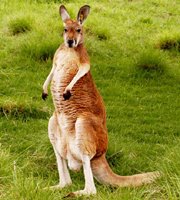
The Eastern Grey Kangaroo (The Reds are almost exclusively on Kangaroo Island.)

The Emu.

Big bird, big poo. (What is it with you, Roger???)

I have a very nice video clip of a koala, but I haven't been able to get a clip to upload to this blog yet. Maybe I'll have more luck when the data isn't traveling thousands of miles to the server.

Darwin
 I'm a bit out of sequence, here, but such is life on the road. Darwin proper has about 110,000 people, but with the suburbs come closer to 150,000. It is growing, with new condos going well into the $700,000 range, and higher. The lifestyle is drawing people more than employment per se.
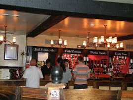
The first pic is of one of the most famous pubs in Australia (from a calendar I saw in the Darwin airport store). It would be very familiar to those Americans who frequent sports bars. Beers were $5, but were a full pint versus the 12 ounces we are used to. Just in case you were curious.
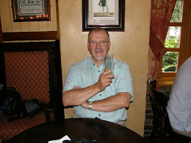
 But across the street was my favorite bar. Too bad they didn't even have coasters with their name on it.
Outside of Darwin is a set of military communications antennae. Darwin has a sizable base that houses the Navy, Air Force and Army, all in the same place. Must make for interesting parades. Anyway, this site is very popular for weddings. Why? For the answer, you'll have to scroll to the end of this post.

Speaking of the military, Darwin was bombed by the Japanese some 64 times (http://www.diggerhistory.info/pages-battles/ww2/darwin.htm) after the attack on our Pearl Harbor. There is a significant emphasis on remembrance in the city, and certain sites are included in a city tour, including tunnels dug to store oil. The tanks in the town had tops painted white, which made them quite visible to the bomber pilots. So rather than do something about that, the local government commissioned the digging of enormous tunnels in which the oil was to be stored. Unfortunately, the digging took so long that the war was over before any oil was pumped in. They are now a tourist attraction. Sorry - no pics of these. But I do include here a picture of a strip of bare ground that runs parallel to the Arnhem Highway, which was an airstrip during WWII. Much of it has disappeared into development and highway, but a long section has been preserved.

As for why the antennae site is so popular for weddings, ...
|
|
|
|
if you marry there, you are guaranteed a good reception.
(I know - I have no shame.)
Wednesday, September 26, 2007
Uluru
OzzieFact:
Geologically, the creation of Uluru and Kata Tjuta were the result of the tectonic movement of the continent away from the Indo-Asian continent and Australia's subsequent travel northward. Western Australia once had soaring peaks, similar to the Himalayas. The rocks in Western Australia are geologically identical, in composition and age, to those of the Himalayas. Erosion took a far greater toll on the Aussie west than on northern India, especially since the Himalayas are even today continuing to be pushed upwards by tectonic movement.
Australia was once covered by an inland sea, but as it separated and began moving northward, it, too, experienced a "pushing up" of the land in the center of the continent. This caused the inland sea to drain. As it did so, there were a few low places or "bowls" into which various sediments were deposited. At the Kata Tjuta site, the heavier boulders and rocks were deposited. At Uluru, the sands. These sites continued to be overlaid with additional and similar material until it all was eventually covered with a huge layer of sediment. Over time, this sediment compressed the underlayments until each site congealed into a conglomerate rock (Kata Tjuta) and a solid rock (Uluru). The covering sediment was worn off or blown away, and the upward push of the land caused the rock at both sites to be thrust above the plains. Uluru was so large and so heavy that it fell onto its side. Geological investigation has proved that Uluru is like an iceberg in that only about 10% of it is exposed.
You can see by the right-hand picture how Kata Tjuta is really conglomerate rock.


And as you can see, Uluru is much more solid, though pock-marked with caves and eroded portions.


This erosion of the Uluru rock face is referred to as "honeycomb erosion," and is sacred to the local people (but we are permitted to photograph it - mainly because it is unavoidable.). It represents an Aboriginal man's face, with his hair flowing out behind his head, which is facing left. The second picture is of the climbing face of Uluru. I chose not to climb, respecting the wishes of the local people.


Sunday, September 16, 2007
Itinerary 18 Sep - 19 October
21 Sep - 24 Sep. = bus tour along The Great Ocean Road, ending in Melbourne.
24 Sep. - 28 (?) Sep. = Melbourne.
28 Sep (?) - Oct. 5 (?) = Tazmania
6 Oct. (?) - 8 Oct. (?) = Canberra.
No later than 12 Oct. = Sydney and possibly points north (Townsville?) for diving. I may wait until January, depending on what I learn in the next week from emailing dice companies. (They wanted me to wait to do this because of tides and other reasons.)
19 Oct. Fly from Sydney to Christchurch, NZ. Interestingly, I am investigating a bus arrangement that allows "on and off" travel. That would save having to buy a car but would sacrifice some degree of flexibility.
More from Adelaide!
Friday, September 14, 2007
Wildlife in the Northern Territories


Thursday, September 13, 2007
Toby & Tanja

Wednesday, September 12, 2007
Jabiru, NT, AU and Arnhem Land (Aboriginal Territory)

A flock of parrots is about the noisiest bunch of birds I've ever heard. They really liked this hotel site.


Don, our guide on the tour, explained the significance of these rock paintings. The last official Rock Painter died 30 years ago, and no local tribal member has been authorized to create this art since. The tradition lives on in other tribes, but supposedly not in this region. The picture of the hand is supposed to reveal a skull in a photograph. Amazingly, it is not visible when viewed directly, but shows up in photos. My shots do not reveal the skull very easily - another tourist got a better image of it - but with time, it appears. Don't feel bad if you cannot see it.

 The river beyond this sign flows 70km to the sea, and is a tidal river. That means that it swells and receeds with the tides. When there is a 7-foot tide, the river rises to as much as 2 meters above the road, washing off semi-trailers whose drivers believe their trucks are heavy enough to make the crossing. There are 15-foot crocs here, but they were too far away and in shadow to make a decent picture. Here's an example, however, from the Holiday Inn Crocodile Hotel:


Wednesday, September 5, 2007
Savute Elephant Camp

 This is right next to our dining area. Although this picture was taken some time ago, this same leopard was drinking here Monday night at about 7:45 as several of us were congregated at the bar. It's wet footprints were still visible when we were alerted to its presence.
One amenity that Savute has that the other two camps does not is an outdoor shower (in addition to the inside shower). Once again, we were cautioned not to use it after 6:30: sundown. For the first time, I regret traveling alone.
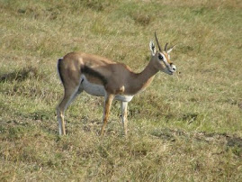
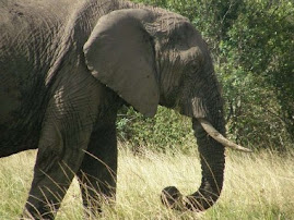
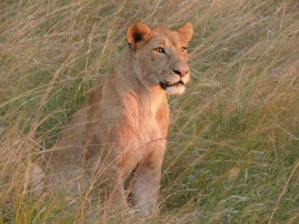
 Finally, on one of our game drives we watched two elephant chase birds away from a waterhole. A small herd of impala approached, but were in alert because in the bush quite nearby were 7 lion, including two males. These lion were quite skittish because there are 3 new and larger male lions in the Chobe National Park breaking up the Savute pride, killing the males, and stealing the females. The males we saw have been hunted for several days, now, and this group moves around quite a bit. Anyway, the elephant eventually left, one of the lions moved too soon and scared off the impala, so the group decided to cautiously approach the water and drink. It took them a full 7 minutes to do so.


